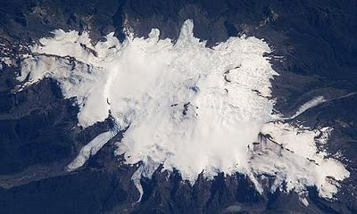
Three major volcanic edifices have been sequentially built up since the mid-Pleistocene over a basement of metamorphic rocks. Tungurahua II was built within the past 14,000 years following the collapse of the initial edifice. Tungurahua II itself collapsed about 3000 years ago and produced a large debris-avalanche deposit and a horseshoe-shaped caldera open to the west, inside which the modern glacier-capped stratovolcano, Tungurahua III, was constructed. Historical eruptions have all originated from the summit crater. They have been accompanied by strong explosions and sometimes by pyroclastic flows and lava flows that reached populated areas at the volcano's base. Prior to a long-term eruption beginning in 1999 that caused the temporary evacuation of the city of Baños at the foot of the volcano, the last major eruption had occurred from 1916 to 1918, although minor activity continued until 1925.
Showing posts with label Geology. Show all posts
Thursday, July 15, 2010
Tungurahua
Tungurahua is an active 5,023m-high andesitic-dacitic stratovolcano which lies in the Andes Central Range of Ecuador. Towering more than 3 km above its northern base, this steep-sided mountain is one of Ecuador's most active volcanoes, giving its name to the province of Tungurahua. Volcanic activity restarted in 1999 and is still going on as of 2010 with major eruptions on August 16, 2006, 6 February 2008, and 28 May 2010. Tungurahua is Quichua word which means "Throat of Fire."
Three major volcanic edifices have been sequentially built up since the mid-Pleistocene over a basement of metamorphic rocks. Tungurahua II was built within the past 14,000 years following the collapse of the initial edifice. Tungurahua II itself collapsed about 3000 years ago and produced a large debris-avalanche deposit and a horseshoe-shaped caldera open to the west, inside which the modern glacier-capped stratovolcano, Tungurahua III, was constructed. Historical eruptions have all originated from the summit crater. They have been accompanied by strong explosions and sometimes by pyroclastic flows and lava flows that reached populated areas at the volcano's base. Prior to a long-term eruption beginning in 1999 that caused the temporary evacuation of the city of Baños at the foot of the volcano, the last major eruption had occurred from 1916 to 1918, although minor activity continued until 1925.
Wednesday, July 14, 2010
Ojos del Salado
Ojos del Salado is a massive 6,891m-high stratovolcano located in the Andes, on the Argentina-Chile border. It is the highest volcano in the world and the second highest mountain in the Western Hemisphere. Ojos del Salado is situated about 600 kilometers (370 miles) north of Aconcagua, the highest mountain in the Western Hemisphere at 6,959 m (22,841 ft).
Due to its location near the Atacama desert, the Ojos del Salado has very dry conditions with snow only remaining on the peak during winter. Despite the generally dry conditions, there is a permanent crater lake about 100 metres (300 ft) in diameter at an elevation of 6,390 m (20,960 ft) on the eastern side of Ojos del Salado. This is most likely the highest lake of any kind in the world.
Ojos del Salado is a recently active volcano. The most recent known eruption was around 1300 years ago. However, there is also some evidence for a minor ash emission in 1993, which would definitely qualify the volcano as historically active. The presence of fumaroles high on the mountain and recent-looking lava flows, albeit of uncertain age, also argues in favor of a categorization as "active."
Due to its location near the Atacama desert, the Ojos del Salado has very dry conditions with snow only remaining on the peak during winter. Despite the generally dry conditions, there is a permanent crater lake about 100 metres (300 ft) in diameter at an elevation of 6,390 m (20,960 ft) on the eastern side of Ojos del Salado. This is most likely the highest lake of any kind in the world.
The ascent of Ojos del Salado is mostly a hike except for the final section to the summit which is a difficult scramble that may require ropes. The first ascent was made in 1937 by Jan Alfred Szczepanski and Justyn Wojsznis, members of a Polish expedition in the Andes. Its name comes from the enormous deposits of salt that, in the form of lagoons or “eyes”, appear in its glaciers.
Ojos del Salado is a recently active volcano. The most recent known eruption was around 1300 years ago. However, there is also some evidence for a minor ash emission in 1993, which would definitely qualify the volcano as historically active. The presence of fumaroles high on the mountain and recent-looking lava flows, albeit of uncertain age, also argues in favor of a categorization as "active."
The first men to successfully climb Ojos del Salado were Polish mountaineers Jan Alfred Szczepanski and Justyn Wojsznis, getting to the summit on February 26, 1937.
Tuesday, July 13, 2010
Caichinque
Caichinque is a Pleistocene-Holocene volcanic complex which is located in the high Andean plateau of the Antofagasta Region, in Chile, between Salar de Talar and Salar de Capur. It lies southwest of the Salar de Atacama, directly S of Cerro Miñiques and SE of Cordón Puntas Negras forming part of the main branch of the Andean volcanic chain in this area.
More than a half dozen vents produced andesitic-to-dacitic lava flows, with young flows descending to the NE and SE from the 4450m-high summit of Caichinque. One prominent flow traveled 6 km to the east, forming two lobes extending into the Salar Talar. Route CH-23 is an approach road to the volcano area.
Monday, July 12, 2010
Batholith
A batholith is a large emplacement of igneous intrusive rock that forms from cooled magma deep in the earth's crust. Batholiths are almost always made mostly of felsic or intermediate rock-types, such as granite, quartz monzonite, or diorite. A batholith is an exposed area of mostly continuous plutonic rock that covers an area larger than 100 square kilometers. Areas smaller than 100 square kilometers are called stocks. However, the majority of batholiths visible at the surface have areas far greater than 100 square kilometers. These areas are exposed to the surface through the process of erosion accelerated by continental uplift acting over many tens of millions to hundreds of millions of years. This process has removed several tens of square kilometers of overlying rock in many areas, exposing the once deeply buried batholiths.
A batholith is formed when many plutons converge to form a huge expanse of granitic rock. Some batholiths are mammoth, paralleling past and present subduction zones and other heat sources for hundreds of kilometers in continental crust. One such batholith is the Sierra Nevada Batholith, which is a continuous granitic formation that makes up much of the Sierra Nevada in California. An even larger batholith, the Coast Plutonic Complex is found predominantly in the Coast Mountains of western Canada, and extends for 1,800 kilometers and reaches into southeastern Alaska.
Batholiths may appear uniform, but they are in fact structures with complex compositions. They are composed of multiple bodies of igneous rock of irregular dimensions, typically at least several kilometers, that can be distinguished from adjacent igneous rock by some combination of criteria including age, composition, texture, or mappable structures. Individual plutons are crystallized from magma that traveled toward the surface from a zone of partial melting near the base of the Earth's crust.
A batholith is formed when many plutons converge to form a huge expanse of granitic rock. Some batholiths are mammoth, paralleling past and present subduction zones and other heat sources for hundreds of kilometers in continental crust. One such batholith is the Sierra Nevada Batholith, which is a continuous granitic formation that makes up much of the Sierra Nevada in California. An even larger batholith, the Coast Plutonic Complex is found predominantly in the Coast Mountains of western Canada, and extends for 1,800 kilometers and reaches into southeastern Alaska.
Batholiths may appear uniform, but they are in fact structures with complex compositions. They are composed of multiple bodies of igneous rock of irregular dimensions, typically at least several kilometers, that can be distinguished from adjacent igneous rock by some combination of criteria including age, composition, texture, or mappable structures. Individual plutons are crystallized from magma that traveled toward the surface from a zone of partial melting near the base of the Earth's crust.
Friday, July 9, 2010
El Solo Volcano
El Solo is a stratovolcano on the border between Argentina and Chile, west of Ojos del Salado. Lying in the Andes Mountain Range, it consists of nine eruptive centers and is covered in light-colored rhyodacite pyroclastic flow deposits. El Solo is 6190-m-high and was the source of major rhyodacitic pyroclastic-flow deposits erupted during the Holocene that thickly fill adjacent valleys.
Thursday, July 8, 2010
Lithophysa
A lithophysa is a spherulitic bubble or cavity found in felsic volcanic rocks and glassy basalts and certain rhyolites. It is believed to be caused by expanding gases in tuffs before solidification. If it has become lined with crystals it may be referred to as a geode or a thunderegg. The word lithophysa is from the Latin for rock bubble. The term vug is also used for similar cavities although vug is usually restricted to mean cavities in rocks formed by the removal of material such as soluble minerals.
Wednesday, July 7, 2010
Maipo Volcano
Maipo is a 17,270ft-high stratovolcano that is situated in the Andes Mountain Range, lying on the border between Argentina and Chile. It is located 90 km (55 miles) south of Tupungato and about 100 km (60 miles) southeast of Santiago. Maipo volcano retains a symmetrical, conical volcanic shape, unlike many of the other nearby peaks, making it the best known peak in the region, though it is not the highest.
Maipo is located within the Diamante Caldera, a feature of about 15 km by 20 km size that is about one-half million years old. It rises about 1,900 m (6,230 ft) above the floor of the caldera. Immediately to the east of the peak, on the eastern side of the caldera floor, is Laguna del Diamante, a picturesque lake that formed when lava flows blocked drainage channels from the caldera in 1826. The Diamante Caldera erupted 450 cubic kilometers (108 cu mi) of tephra, 450 ka.
The region's climate is transitional between the drier Mediterranean climate of the peaks to the north and the cold, moist climate of Chilean Patagonia. Hence, while less glaciated than Patagonia, it has more permanent snow (on the wet, Chilean side) than peaks of similar elevation to the north.
Tuesday, July 6, 2010
Socompa
Socompa is a 6051m-high dacitic stratovolcano lying in the Andes Mountain Range, in the province of Salta, on the border of Argentina and Chile. It is best known for its large debris avalanche deposit, which is widely accepted as the best-preserved example of this type of deposit in the world, and also notable as the home of the world's most elevated known microbial ecosystems.
The western rim of Socompa volcano is bounded by the Monturaqui Basin, which is draped with the aforementioned deposit. Escondida Mining currently has a network of roads throughout this area, from beneath which they pump ground water for use at the nearby copper mine. The southern margin of the deposit is bordered by the Antofagasta to Salta trans-Andean railway, although this is rarely used.
Socompa is difficult to reach - either from the north along dirt tracks south of the Miscanti Pass, or from the west via the Escondida copper mine. Both routes require a full-day's driving and for any reasonable amount of time to be spent at Socompa would need significant planning.
Monday, July 5, 2010
Lanin Volcano
Lanin is a 12,293ft-high, cone-shaped stratovolcano on the border of Argentina and Chile. It is part of two national parks: Lanín in Argentina and Villarrica in Chile. It is a symbol of the Argentine province of Neuquén, being part of its flag and its anthem. Although the date of its last eruption is not known, it is estimated to have occurred within the last 10,000 years.
The ascent is regulated by the management of Argentine National Parks and the Argentine National Gendarmerie, and is relatively simple, but many deaths have occurred due to lack of responsibility and caution of the climbers. The nearest towns, usually employed as a base for climbers, are Pucón in Chile and Junín de los Andes in Argentina.
There are two paths to the summit: one on the north, starting at 1,200 above mean sea level near Lake Tromen and the international Mamuil Malal Pass, accessible via Neuquén's Provincial Route 60; and one on the south, starting beside Lake Huechulafquen, accessible via Provincial Route 61.
Saturday, July 3, 2010
Krakatoa Volcano
Krakatoa is a volcano in the Sunda Strait between the islands of Java and Sumatra in Indonesia. The best known eruption of Krakatoa culminated in a series of massive explosions on August 26–27, 1883, which was among the most violent volcanic events in modern and recorded history. With a Volcanic Explosivity Index (VEI) of 6, the eruption was equivalent to 200 megatons of TNT (840 PJ)—about 13,000 times the nuclear yield of the Little Boy bomb (13 to 16 kT) that devastated Hiroshima, Japan during World War II and four times the yield of the Tsar Bomba (50 MT), the largest nuclear device ever detonated.
The 1883 eruption ejected approximately 21 cubic kilometres (5.0 cu mi) of rock, ash, and pumice. The cataclysmic explosion was distinctly heard as far away as Perth in Western Australia, about 1,930 miles (3,110 km) away, and the island of Rodrigues near Mauritius, about 3,000 miles (5,000 km) away. Near Krakatau, according to official records, 165 villages and towns were destroyed and 132 seriously damaged, at least 36,417 (official toll) people died, and many thousands were injured by the eruption, mostly from the tsunamis that followed the explosion. The eruption destroyed two-thirds of the island of Krakatoa.
Eruptions at the volcano since 1927 have built a new island in the same location, named Anak Krakatau (Indonesian: "Child of Krakatoa"). This island currently has a radius of roughly 2 kilometres (1.2 mi) and a high point around 300 metres (980 ft) above sea level, growing 5 metres (16 ft) each year.
The 1883 eruption ejected approximately 21 cubic kilometres (5.0 cu mi) of rock, ash, and pumice. The cataclysmic explosion was distinctly heard as far away as Perth in Western Australia, about 1,930 miles (3,110 km) away, and the island of Rodrigues near Mauritius, about 3,000 miles (5,000 km) away. Near Krakatau, according to official records, 165 villages and towns were destroyed and 132 seriously damaged, at least 36,417 (official toll) people died, and many thousands were injured by the eruption, mostly from the tsunamis that followed the explosion. The eruption destroyed two-thirds of the island of Krakatoa.
Eruptions at the volcano since 1927 have built a new island in the same location, named Anak Krakatau (Indonesian: "Child of Krakatoa"). This island currently has a radius of roughly 2 kilometres (1.2 mi) and a high point around 300 metres (980 ft) above sea level, growing 5 metres (16 ft) each year.
Wednesday, June 30, 2010
Michinmahuida
Michinmahuida is a glaciated stratovolcano located in Los Lagos Region of Chile. It situated about 15 km east of Chaiten volcano, and was extensively covered in ash during the 2008 eruption of Chaiten. The Michinmahuida lies above the regional Liquine-Ofqui Fault zone, and the ice-covered massif towers over the south portion of Pumalín Park. The Michinmahuida volcano is also known as Michinmávida or Michimahuida.
Aerial View of Michinmahuida
Two major explosive eruptions of the Michimahuida during the Holocene produced tephra deposits extending to the east. An eruption from Minchinmávida was reported in 1742. Darwin observed the volcano in activity in 1834 on his renowned voyage that took him to the Galápagos Islands. The latest known eruption of basaltic-to-andesitic Minchinmávida, from February to March 1835, produced a lava flow from a flank crater and lahars that reached the coast at Punta Chana.
Tuesday, June 29, 2010
Isluga Volcano
Isluga is a 18,209ft-high stratovolcano which lies in Colchane, 7 km west of the Chile/Bolivia border and at the west end of a group of volcanoes lined up in an east-west direction, which also includes the volcanoes Cabaray and Tata Sabaya. Isluga has an elongated summit area and lies within the borders of Volcán Isluga National Park. Isluga is a large elongated volcanic complex, which currently shows fumarolic activity. On top of it summit there is a a 400 m wide crater. Major eruptions occurred in 1868, 1869, 1877, and 1878. Minor eruptions occurred in 1863 and 1885. Sulphur is deposited at the volcano base. Some activity was reported in 1913.
Satellite Photo of Isluga Volcano
Monday, June 28, 2010
Nevado del Huila
Lying in Cordillera Central mountain range, in Huila Department, the Nevado del Huila is the highest active volcano in Colombia. It is 5,365 meters (17,602 ft) high and had been dormant for more than 500 years until it showed heavy signs of activity in 2007 and 2008. As of February 20, 2007, there were more than 7000 "minor" seismic events, and a high state of alert was in place for the departments of Cauca, Huila, Caldas and Valle del Cauca.
The Nevado del Huila volcano erupted twice in April 2007, once in April 2008 and again in November 2008. Any eruption would affect the small villages around the volcano, mostly Paez, Cauca, where their habitants still have in memory the eruption of the Nevado del Ruiz volcano and the destruction of Armero. The high point of the Nevado del Huila complex is Pico Central. Two glacier-free lava domes lie at the southern end of the complex.
Saturday, June 26, 2010
Nevado del Tolima
Nevado del Tolima is a 5,225-meter-high stratovolcano which is situated in the Tolima Department, Colombia. It lies to the south of Nevado del Ruiz volcano.
The steep-sided, glacier-clad Nevado del Tolima volcano contrasts with the broad profile of Nevado del Ruiz volcano to the north. The andesitic-dacitic younger Tolima volcano formed during the past 40,000 years, rising above and largely obscuring a 3-km-wide late-Pleistocene caldera. The summit consists of a cluster of late-Pleistocene to Holocene lava domes that were associated with thick block-lava flows on the northern and eastern flanks and extensive pyroclastic-flow deposits.
The Nevado del Tolima summit has a funnel-shaped crater 200–300 m deep. Holocene activity has included explosive eruptions ranging in size from moderate to plinian. The last major eruption took place about 3600 years ago. Lava dome growth has produced block-and-ash flows that traveled primarily to the NE and SE. Minor explosive eruptions have been recorded from Tolima in the 19th and 20th centuries.
Friday, June 25, 2010
Aucanquilcha
Aucanquilcha is a massive stratovolcano located in Antofagasta Region of northern Chile, just west of the border with Bolivia. It is 6,176 m (20,262 ft) high and comprises a number of overlapping cones along a 10 km (6 mi) long ridge that forms the summit. There is weak, episodic fumarolic activity and voluminous sulfur deposits in the summit region. During the Pleistocene ice ages, an extensive ice cap with an area over 45 km² (17 mi²) mantled the upper slopes, extending down as low as 4,600 m (15,000 ft) and leaving large moraines.
A sulfur mine, owned by the Carrasco family, was located near the summit of Aucanquilcha, which was the world's highest mine until it closed in the 1990s, and it was serviced by perhaps the highest driveable road in the world, but this road is no longer usable by vehicles. The highest permanent human habitation was a miners' barracks at about 5,500 m (18,000 ft). Mining originally began on the volcano in 1913, initially using llamas as pack animals to carry down the sulfur. An aerial cable system extending for 22 km (14 mi) was completed in 1935, to lower the sulfur in buckets. Eventually this was replaced by the road which switchbacked up to the summit and was capable of supporting 20-ton mining trucks.
Thursday, June 24, 2010
Protolith
Protolith is the original, sedimentary rock from which a metamorphic rock is formed. It refers to the precursor lithology of a metamorphic rock. For example, the protolith of a slate is a shale or mudstone. Metamorphic rocks can be derived from any other rock and thus have a wide variety of protoliths. Identifying a protolith is a major aim of metamorphic geology. Sedimentary rocks have no protolith because they are made of sediment. Igneous rocks have no protolith because they form from magma.
Wednesday, June 23, 2010
Acotango Volcano
Acotango is stratovolcano lying on the border of Chile and Bolivia. It is 19,856 ft high and is the central and highest of a group of stratovolcanoes in the area. The group is known as Nevados de Quimsachata and consists of Acotango, Humarata (18,799 ft) to its north and Cerro Capurata (19,652 ft) on its south. This group of volcano lies in a north-south direction. Although the Acotango volcano is heavily eroded, a lava flow on its northern flank is morphologically young, suggesting Acotango was active in the Holocene.
Tuesday, June 22, 2010
Sheet Intrusion
A sheet intrusion is a mass of molten (when forming) or solidified (after formation) igneous rock that takes advantage of a pre-existing linear feature in a host rock, such as a long rupture or fault. Sheet intrusions are among the most extensive igneous features on Earth, in the form as dikes, dike swarms, laccoliths, and sills.
Monday, June 21, 2010
Laccolith
A laccolith is a sheet intrusion that has been injected between two layers of sedimentary rock. It is a small area that broke away from the main area of magma but did not have the pressure to break through the surface. In other words, a laccolith is a small magma chamber which has formed near the surface. The pressure of the magma is high enough that the overlying strata are forced upward, giving the laccolith a dome or mushroom-like form with a generally planar base.
Laccoliths are formed by relatively viscous magmas at relatively shallow depths, such as those that crystallize to diorite, granodiorite, and granite. Cooling underground takes place slowly, giving time for larger crystals to form in the cooling magma. The surface rock above laccoliths often erodes away completely, leaving the core mound of igneous rock. The term was first applied as laccolite by Grove Karl Gilbert after his study of intrusions of diorite in the Henry Mountains of Utah in about 1875.
At places, such as in the Henry Mountains and other isolated mountain ranges of the Colorado Plateau, some intrusions demonstrably have shapes of laccoliths. The small Barber Hill syenite-stock laccolith in Charlotte, Vermont USA, has several volcanic trachyte dikes associated with it. Molybdenite is also visible in outcrops on this exposed laccolith.
Saturday, June 19, 2010
Lopolith
A lopolith is a large igneous intrusion which is lenticular in shape with a depressed central region. In other words, it is a mass of igneous rock similar to a laccolith but concave downward rather than upward. Lopoliths are generally concordant with the intruded strata with dike or funnel-shaped feeder bodies below the body. The term was first defined and used by Frank Fitch Grout during the early 1900s in describing the Duluth gabbro complex in northern Minnesota and adjacent Ontario.
Lopoliths typically consist of large layered intrusions that range in age from Archean to Eocene. Examples include the Duluth gabbro, the Sudbury Igneous Complex of Ontario, the Bushveld igneous complex of South Africa, the Skaergaard complex of Greenland and the Humboldt lopolith of Nevada. The Sudbury and Bushveld occurrences have been attributed to impact events and associated crustal melting.
Subscribe to:
Posts (Atom)